
Spring on the Charles River
By: shortfinals
Tags: 'Quinobequin', (1600-1649), 1580-1631, 1614, 1639, 1760, 1896, 80 mile course, a European scale, Aix sponsa, Alewife, Alosa aestivaris, Alosa pseudoharengus, anadromous fish, annual spring/summer run, beautiful scenery, Beaver, bed of daffodils, Blueback Herring, Boston, Broadmoor Wildlife Sanctuary, Cambridge, canoes, Captain John Smith, Castor canadensis, Charles 1st, Charles River, Commonwealth of Massachusetts, daily commute, dams across the Charles River, earliest of America's cities, Echo Lake, England, erected in 1934, fish ladders, fisherman, flood control, Greater Boston, Greater Boston area, grind corn, grind grain, gritstone, Hopkinton, how to grow maize, Indian name, kayaks, King of England, largest conservation organisation in Massachusetts, local Indian tribes, many bridges to negotiate, Massachusetts, Massachusetts Audubon Society, Massachusetts Bay Colony, Massachusetts Route 16, Matthew Hastings, meanders to the sea, millwheel, New England, original native name, Pilgrim settlers, protecting wildlife, quiet elegance, rich in wildlife, River Charles, river frozen over, river herring, rivers of New England, rowing boats, run up New England rivers to spawn, salmon, scoop up the fish with a net, snowmelt, source of the Charles River, South Natick Dam, spend most of their life in the sea, Spring, Spring in New England, stone dam, swollen by snowmelt, the wanderer, timber dam, town of Natick, Town of Wellesley, two local species, USA, water power, Wood Duck
Category: England, New England, Plants, Royalty, United States
| Aperture: | f/7.1 |
|---|---|
| Focal Length: | 18mm |
| ISO: | 200 |
| Shutter: | 1/0 sec |
| Camera: | NIKON D40 |
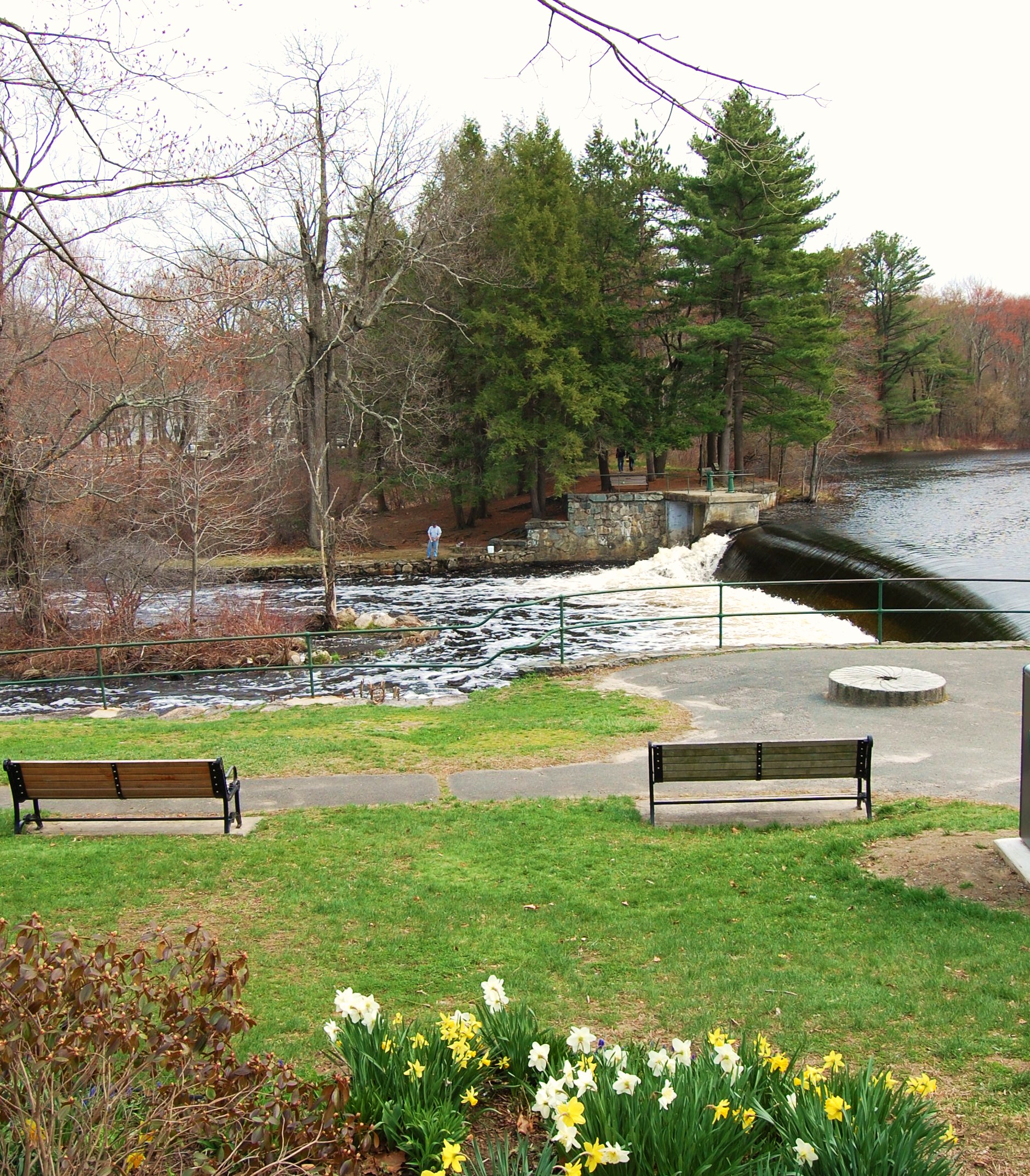
Spring in New England comes swiftly; only a few weeks prior to this photograph being taken, the Charles River was frozen over, and it seemed barely possible that this is usually, for most of the year, a delightful thoroughfare for canoes, kayaks and rowing boats. The Charles River (sometimes refered to as the River Charles) divides one of the earliest of America’s cities, Boston, from Cambridge on the opposite bank, and since the Greater Boston area is split by the river, there are many bridges to negotiate during a daily commute (even I cross at least one of them!) The river was surveyed, in part, by Captain John Smith (1580-1631) during his voyage to the Massachusetts Bay Colony in 1614. He named the Charles River after the King of England, Charles 1st (1600-1649). The Indian name for the river was thought to be ‘Quinobequin‘ (the wanderer) referring to the way that the river’s 80 mile course meanders extravagantly to the sea, which is only 26 miles distant from it’s source at Echo Lake, Hopkinton. However, there is some dispute regarding the original native name amongst scholars, and no definitive answer is forthcoming as yet.
Dams have been constructed across the Charles since as early as 1639. Water power was used to grind corn (the settlers had been shown how to grow maize by the local Indian tribes), and to provide power for many other uses. The dam shown above is the South Natick Dam on the Charles, a fine stone structure erected in 1934 by the town of Natick. It is on the site of an earlier timber dam, built in about 1760 by one Matthew Hastings. The original dam was obviously used to grind grain, as shown by the commemorative gritstone millwheel, which is set in the ground on the west bank of the river. The current dam is used for flood control – the rivers of New England are often swollen by snowmelt. Only a few weeks ago, the river upstream of this dam was frozen from side to side, but now you can see a bed of daffodils making a bright show.
The Charles is rich in wildlife; a short distance upstream from the dam is the Broadmoor Wildlife Sanctuary where you can view Wood Duck (Aix sponsa) and Beaver (Castor canadensis). It is administered by the Massachusetts Audubon Society, the largest conservation organisation in the Commonwealth of Massachusetts (the official name of the State), which has been protecting wildlife in the area since 1896. If you look closely you can see a fisherman on the far bank. The annual spring/summer run of the river herring has begun (although it is easier – and legal – to scoop up the fish with a net)! There are two local species of this anadromous fish (this means that, like salmon, they spend most of their life in the sea, and run up New England rivers to spawn in freshwater) and they are, indeed, rather delicious, as the early Pilgrim settlers found. Both the Alewife (Alosa pseudoharengus) and the Blueback Herring (Alosa aestivaris) navigate around the dams on the river by means of ‘fish ladders’, a series of small chambers which the fish can negotiate one at a time. If you look to the far bank of the Charles you will see a fish ladder, but sadly, the flow is rather too strong (the ladder’s ‘steps’ are very much overfilled) for fish to make an easy ‘run’ up it.
I like the Charles; it has a quiet elegance, and a European scale to it. If you get a chance to drive down Massachusetts Route 16 from the town of Wellesley, you will be rewarded with some beautiful scenery at any season of the year!


Leave a comment